


| |
Comment: Photographs taken from various locations around Camarillo, CA Click thumbnail for a full screen picture 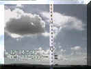 | A protractor is superimposed on the photograph of a flying airplane. This airplane was calculated to be 66 feet above ground level. Each blue or white segment on the protractor is equal to 1 degree. Laguna Peak in the background is 2.01 degrees above the horizon from the camcorder's location. The airplane is 5.6 degrees above the horizon. The 66 feet AGL calculation appears to be correct if you assume the airplane is about 33 feet long. The airplane is about two airplane lengths (2*33 ft= 66 ft) above the horizon. The black numbers on the picture are the pixel measurements read after using a video capture card to digitize the picture. 12.5 pixels= 1 degree. | 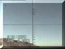 | The moon at 3:21 p.m. on Jan. 23, 2001, at Point Mugu, CA. The elevation angle of the moon is measured from the water's edge to the moon. I read the elevation angle to be 39.9 degrees. The U.S. Naval Observatory's data for this time, date and place for the moon's elevation angle is 39.9 degrees. To read the degrees count up the number of tick marks from just above the water's edge (horizon). Each tick mark is equal to 1 degree. | 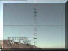 | The moon at 3:27 on Jan. 23, 2001, at Point Mugu, CA. The elevation angle of the moon is measured from the water's edge to the moon. I read the elevation angle to be 35.0 degrees. The U.S. Naval Observatory's data for this time, date and place for the moon's elevation angle is 35.0 degrees. To read the degrees count up the number of tick marks from the just above the water's edge (horizon). Each tick mark is equal to 1 degree. | 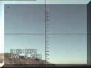 | The moon at 3:32 on Jan. 23, 2001, at Point Mugu, CA. The elevation angle of the moon is measured from the water's edge to the moon. I read the elevation angle to be 36.0 degrees. The U.S. Naval Observatory's data for this time, date and place for the moon's elevation angle is 36.0 degrees. To read the degrees count up the number of tick marks from the just above the water's edge (horizon). Each tick mark is equal to 1 degree. | 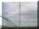 | These two next pictures were taken during "Low Flying Aircraft Monitoring System's" Validation tests. . These two pictures were taken at the same time. You can tell this by the camcorder's date/time tag on the picture are both Nov 25,2000, 9:55:29. Also, there is another way to tell if these two photographs were taken at the same time without the date/time tag. When the two cameras are aligned directly at each other there is only one instant in time when the aircraft is directly between the two camcorders. | 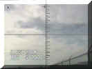 | This is a picture of the same aircraft but facing south. The peak in the background is Laguna Peak which is 2.01 degrees above the horizon from this location. The picture above this one is facing north. The peak in the background is Hines Peak which is 3.37 degrees above the horizon from this location. A laser range finder was used during the Validation tests. The laser range finder's altitude reading and the "Low Flying Aircraft Monitoring System's" altitude calculation agreed within 3 feet for this series of tests. |
 | This is a photograph of a giant protractor with a radius of 57.3 inches. It is viewed from the center of the giant protractor. Each segment of the blue or the white on the pole is equal to one degree. Although the object in the middle of the picture appear to be a blue-and-white-barber pole, it is actually part of the circumference of a circle rising up over the camcorder. |
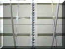 | This is the same protractor as in the photograph above with the video template superimposed on it. The video template was created using data digitized of photographs of objects with known angle measurements. One of these known-angle photographed objects is the pictures of the moon (see above). The U.S. Naval Observatory publishes the elevation angle measurements of celestial objects. These elevation angles are used to determined the latitude and longitude on the earth surface using a sextant. |  | This is a photograph of a vertical ruler 94.5 inches away. Every six inches of the ruler is marked with a blue tape. The angle in degrees of the camcorder to the ruler is equal to ATAN(number-of-inches-up-the-vertical-ruler/94.5 inches). |  | This is the same vertical ruler as in the photograph above with the video template superimposed on it. The video template was created using data digitized of photographs of objects with known angle measurements. One of these known-angle photographed objects is the pictures of the moon (see above). The U.S. Naval Observatory publishes the elevation angle measurements of celestial objects. These elevation angles are used to determined the latitude and longitude on the earth surface using a sextant. |  | This is a photograph of the sun above an artificial horizon. The sun is the small round object in the middle of the picture. The large black rectangle object is a (#14 welders) shade filter. The curved line on the extreme bottom of the screen is actually a straight-edge level when viewed through a 3.9 mm camcorder lens. The blue and white striped target just above the level is the artificial horizon. Each blue line is equal to 1 degree above the horizon. |
| These are the video template used for different backgrounds The black one is used for night time use. Each line is equal to 1 degree. |
|