LOWFLYING AIRCRAFT MONITORING SYSTEM
The FAA has given the responsibility
of handling aircraft noise complaints to the airports,
but the FAA has not given the airports any authority to solve the problem Why are the county airports unnecessarily reducing the homeowners property values and quality of life? Why don't the FAA or Ventura County Airport officials enforce their own regulations? Why don't the airport officials enforce their own noise abatement procedures? Why don't the noise abatement procedures have a single mention of any noise level restrictions? For the answer to these and other burning questions, please see the Frequently Asked Questions (FAQ) page. FOR A SHORT, NON-TECHNICAL  OVERVIEW, PLEASE GO TO OVERVIEW, PLEASE GO TO
MY SOAPBOX |
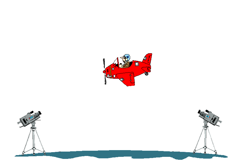
This web site would not be necessary if the pilots would follow the FAA's regulations designed to keep airplanes at a height above homes as to minimize noise problems. Some important noise reduction regulations and procedures are not being enforced by the Air Traffic Control tower (ATCT) or by any Ventura County Airport agency. There is a FAA regulation which states that an aircraft coming in for a landing should stay at or above the glide-slope. The pilots have a Precision-Approach-Path-Indicator (PAPI) at both county airports that lets them know visually if they are on or above the glide-slope.The FAA's Flight Standards District Office (FSDO) in Van Nuys is responsible for enforcing this flying the glide-slope requirement. They rely upon the citizens to report these low flying aircraft. The FSDO requires the reporting citizen to provide the proof that the aircraft was flying too low. But what sort of proof can a citizen supply? How can a citizen determine and prove that a particular plane is flying too low? Neither the FAA nor Ventura county plans to have anything in place to find out if the airplanes are following this PAPI requirement. Their attitude appears to be that a plane isn't being flown too low until and unless it hits something on the ground. There is an accurate, economical and easy to use way that has been developed to measure the altitude of airplanes that are deemed flying too low, verifiable proof of altitude and the ability to identify the airplane. All we need now are elected officials with the political will to put this tool to work. This web site describes one possible solution for monitoring low flying airplanes.
Accurate: The height of the aircraft is determined by solving a basic triangle using high school geometry. The triangle is formed by the two camcorders forming the base and the airplane being the peak. There are three sources of information used to solve for height. Firstly, a Global Positioning Satellite (GPS) receiver to determine the camcorders' locations. Secondly, the U.S. Geological Survey Quadrangle map and the Ventura County Department of Horizontal Measurement to determine the altitude of the camcorders. And thirdly, the U.S. Naval Observatory celestial data is used to determine the angle measurement of the aircraft from the horizon. The celestial object's position that was recorded previously on videotape is compared with the aircraft's position on the videotape to determine the aircraft's angle above the horizon. The accuracy of determining the altitude is +/- 10.3 feet for an airplane 2000 feet away.
economical: Less than $3000 for equipment | 2 Closed Circuit TV cameras (CCTV) @$550 | $1100 | | 2 Lens for CCTV cameras @$100 | $ 200 | | 2 TV's @$100 | $ 200 | | 9 VCR's @$100 | $ 900 | | 4 Tripods @$ 40 | $ 160 | | 1 Air Traffic Radio Receiver @$100 | $ 100 | | Various cables | $ 150 | TOTAL COST OF SYSTEM | $2810 |
Easy to Use: There are four VCR's at each camera site to record 24 hours of data each day. Each VCR records six hours of data during the same period each day. The VCR's videotape is played back on the TV's screen where the angle to the aircraft is measured on the screen. The altitude of the aircraft may then be figured out.
Politics: I must be doing something right because I touched some sensitive political nerves. I've managed to get a lot of local officials upset at me. This web page will report on the political process for getting the pilots to follow the FAA regulations.On this website I will be detailing my often frustrating efforts to gain the attention of the several political entities involved in enforcing the FAA regulations. Months of foot-dragging, downright obstruction and bureaucratic smokescreens have led me to seek a more public forum for my efforts. |